Wednesday, January 19, 2011

Camp Pilot Knob

Crossing Imperial County – Stop #8  

From the
Plank Road
we head east on I-8 to Felicity and Camp Pilot Knob and get an extra roadside attraction thrown in. Felicity is named after Jacques-Andre Istel’s wife Felicia, and Jacques-Andre somehow got Imperial County to incorporate it as a town with a population of two. Felicity is also the center of the world and a pyramid that you can walk into marks the spot to stand on. Jacques-Andre has received recognition from several otherwise reasonable counties, including his native France that this is indeed ground zero. Jacques-Andre is also recognized as the father of skydiving in the US. Man, there’s a pony in here somewhere.
The nature of the stop however is Camp Pilot Knob and it’s just east of the center of the world and one of seven of the ‘985’s’……the series of Desert Training Centers of World War II.  And training was tough. One exercise was a mile run in the midday heat with full gear and rifle and it had to be done in under 10 minutes.   

Camp Pilot Knob
August 17, 1944
Anne Darling,  What a week this has been so far. I have so much to tell you I don't know where to start. Last night we went on a night problem on compass reading. I was picked as patrol leader of patrol #11. There were six patrols of 10 men each in our platoon. I was responsible for these men and getting back in time. After the long hike on Tuesday night we were in no mood for another last night but we all did it.   - Your ever loving husband, Joe


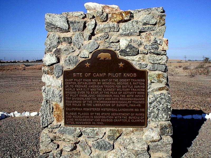
Plaque Inscription: State Historical Landmark No. 985
DESERT TRAINING CENTER, CALIFORNIA-ARIZONA MANEUVER AREA (ESTABLISHED BY MAJOR GENERAL GEORGE S. PATTON, JR.) - CAMP PILOT KNOB
Camp Pilot Knob was a unit of the Desert Training Center, established by General George S. Patton, Jr., to prepare American troops for battle during World War II. It was the largest military training ground ever to exist. At the peak of activity here at Pilot Knob, June-December, 1943, the 85th Infantry Division, and the 36th and 44th Reconnaissance Squadrons of the 11th (Mechanized) Cavalry trained here for roles in the liberation of Europe, 1944-5


Location: Sidewinder Rd, 200 yds North of I-8, town of Felicity (.25 mi. East of the 'Center Of The World' attraction). 
Google maps: 32.748986,-114.754686
Camp Pilot Knob is 11.5 miles from
Plank Road
This is virtually the same song as ‘Training Center Boogie’ and can be viewed here:


PILOT KNOB BOOGIE

Well the sun's gone down I got a minute to write
A letter to you mama here by candlelight
No sheets on my cot in this tent we're in
Somebody said today it was 110
No refrigerator no electricity
At Camp Pilot Knob that's the way it has to be

You know I joined this army to get into the war
And I'm training the desert, June of 1944
Dancin' with the cactus do the shuffle with the sand
Do the swing with the buzzards jitterbug when we can
But there's a special one we do and it's a goodie
A little jive dance they call the Pilot Knob boogie

Chorus - Pilot Knob boogie's not a dance you see
A mile run in the sun when it's 103
Full pack and a rifle here we go again
Get it out this minute, get it in under ten

We're getting up tomorrow at a quarter to four
Marching to the border on the desert floor
Then it's rations with a passion in the noonday sun
Can't wait to get started it really sounds like fun
March back to the camp in the afternoon
Thank you Mr. Sergeant for this lovely day in June

Waitin' for the minute when the order comes around
We're going of to Europe, put old Hitler down
This 85th division of the infantry
Gonna dance on Hitler's grave for everyone to see
Cause there's a special one we do and it's a goodie
A little jive dance we call the Pilot Knob boogie


Monday, January 17, 2011

The Old Plank Road

Crossing Imperial County – Stop #7


Red sand, white sand, take your choice in the Algodones Dunes of Imperial County, or what off roaders loosely call Glamis. The reddish sands of northeast portion are stunning and the subject of countless commercial photo shoots. The caddy however is headed south out of Holtville to the interstate and the white stuff at Gray’s Well.
Grandfather on the harmonica

“It was back in ’17 and I was moving to California for good,” my grandfather said. “And I thought being chased by an Indian gang in Arizona was an adventure, but the strangest thing was the miles of wooden plank road they’d put over the desert sand dunes as we tried to stay on the narrow planks with the wind trying to sweep us away.” It was a great story but his photos indicate that he came to California well north of there through Needles. Most likely his plank road trips were done when he came out to camp and prospect, panning the western banks of the Colorado River in following years. Sand dunes did prove to be a nemesis for him as on two occasions in Saudi Arabia, he stranded Aramco red company Fords deep in the open desert for days, to be luckily rescued by caravans.


From the ‘Landmarks of Imperial County’ album booklet:
From 1914 to 1927 the plank road along with the new bridge over the Colorado at Yuma provided a faster route to Phoenix from San Diego than Los Angeles. Though they'd hang a tire off a pole so you could see the turnouts, fistfights would still break out over right-of-way. In spite of the hardships, some people enjoyed the adventure and would come just to ride across and picnic at Gray's Well.  Children loved the bumpy ride. When engineers determined that the high sand hills could support the weight of concrete and asphalt they began construction of a two-lane road over the dunes in 1926.


Plaque Inscription:
No. 845 PLANK ROAD
This unique plank road, seven miles long, was the only means early motorists had of crossing the treacherous Imperial sand dunes. The 8-by-12-foot sections were moved with a team of horses whenever the shifting sands covered portions of the road. Double sections were placed at intervals to permit vehicles to pass.
Location: Algodones Sand Dunes County Rest Area, South side of I-8 (P.M. 77.4), 18 miles West of Winterhaven.   Note: Plaque was removed from rest area and is on South side of Gray's Well Road, 3.3 miles West of intersection with I-8, 18 miles West of Winterhaven.  At the plaque site are examples of the plank road.
Google maps: 32.710282,-114.92424
Plank Road is 38 miles from Tecolote Rancho


Here’s a link to a video of the song:


OLD
PLANK ROAD
 

Out in the desert where the Vulture flies, there's an ocean of sand so high
Goes in length nearly 50 miles, and stretches nearly 7 miles wide

The hard winds blow like driven snow, and grit gets into your eyes
And the sand it drifts like waves at sea, and there ain't no place to hide

Folks needed to cross with their automobiles, to drive around it was too slow
So over the top like a wooden snake, that's where they put the
Old Plank Road

Chorus -
The
Old Plank Road
was mighty chancy, and the
Old Plank Road
was thin
Eight feet wide from side to side, when will this wooden road end?
Thumpin' and a-bumpin' shakin up an down, rattle like your shakin' up a can
On the other side things do subside, daddy can we take the road again?

In 1916 they built the old road, out of seven miles of wooden crossties
Held together with bars of steel, for the cars and trucks to ride

You may ask yourself what did they do, when a car would come the other way
Every 1000 feet they put in a turnout, so you could scoot aside and get away

There's a story 'bout the man in an eastbound car,
so stubborn he refused to yield
20 westbound cars stuck on the road, they went and got his automobile

They picked it up and put him in the sand, and the westbound cars got by
Picked it up again and put it on the road,
and waved a not too pleasant good bye

  If you're crossing the desert by old Gray's well, out on interstate eight
Take a look around at the
Old Plank Road
before the sand takes it all away


Saturday, January 15, 2011

Tecolote Rancho

Crossing Imperial County – Stop #6
We head to Holtville, the carrot capitol, and Imperial County’s newest state landmark. Once there, place your hand on the golf ball embedded in cement atop the landmark and as legend states, your game will improve by three strokes.  

William F. Holt, perhaps the inspiration for Jefferson Worth, Barbara’s foster parent in the novel
The Winning of Barbara Worth’ was an entrepreneur of Imperial Valley (Holtville) and the person most responsible for bringing author Harold Bell Wright to the region. Mr. Holt shows up in 1888 as a developer out of Riverside in another original song about ‘Palmdale’ a failed endeavor in the Coachella Valley. Follow this guy around and you’ll learn a lot about the development of the region and centralized agriculture.  

From the album booklet:
Few people define a career decision vividly as did Harold Bell Wright in August 1909. This 1909 account from the El Centro Daily Free Lance:

Torn by conflicting demands on his aesthetic nature by two separate artistic callings Harold Bell Wright, novelist and painter, chose between the two last week in his home at Tecolote Rancho east of El Centro. Hoping to put forever behind him the painter part of his artistic nature, Mr. Wright went to his studio and ruthlessly tore down and carried out every picture he had painted, every canvas he had sketched, his easels, frames, studies, all his oils and colors, his palate and knife, his turpentine, mahl stick, sketch books and water colors and threw them all in one big heap; then he touched a match to the heap.

Plaque Inscription: No. 1034 SITE OF RANCHO EL TECOLOTE
Prolific author Harold Bell Wright purchased 160 acres in 1907.  While living in a tent he built Rancho El Tecolote constructing a woven arrow weed studio in 1908 and a ranch house in 1909.  From 1907 to 1916 he wrote three best sellers, including the historical novel "The Winning of Barbara Worth," a chronicle of desert reclamation and the Colorado River flood of 1905.  As Wright's most successful and important book, it brought and it's agricultural wealth to the attention of the nation.  The book's heroine Barbara Worth became an icon for the region.

Location: Off S-80, South on
Country Club Dr.
(between Barbara Worth and Calexico Rds.).  Proceed .25 miles south. 
Google maps: 32.800136,-115.421698
Tecolote Rancho is 14 miles from Camp Salvation

Here’s a link to a video sample of the song:


TECOLOTE RANCHO

A small twist of fate in nineteen hundred and eight
Brought Herald Bell Wright to the valley so new
To write and to paint, devote his life to creating
Scenes of this desert he knew

Chorus - Oh the stars look so clean, your lost in a dream
As the moonlight falls on your poncho
Musical words they did play the whole night away
The waltz of Tecolote Rancho

It proved too much to try he had to decide
Painting or writing which one to pursue
But a vision it came in a rare summer rain
In an instant he knew what to do

Took his easels and frames, his paintings of the range
Palates and brushes to a pile he did throw
And this artistic pyre he set it on fire
And watched as it went up in smoke

(Chorus)

Herald Bell Wright would only be writing
Evermore to create his painting with words
And from this little town he became world renown
Let’s be thankful that fire occurred


Friday, January 14, 2011

Camp Salvation

Earthquake Rocks Calexico!
In truth, this is about the rare occurrence of a landmark being relocated, and since the April 10, 2010 quake moved all of Calexico 31 inches, it seems like a natural transition….and a way to use a very cool movie stock photo.

      July 1993 
      October 2003

Crossing Imperial County – Stop #5

From Fort Pacheco it’s east on
Worthington Road
, then south on Highway 86 through El Centro (land of Cher) to interstate 8 east, then south on Highway 111.

Highway 111 runs through the heart of Calexico just like it runs through the heart of Palm Springs. From interstate 10 near Whitewater to the international border at Calexico, highway 111 takes in about everything the Colorado Desert has to offer, yet it’s doubtful the entire 129 mile stretch is ever driven as a whole by a single driver.   


From the album booklet:
Actually the plaque has been moved sometime since the first visit here 1993 due to the construction of the new Calexico City Hall and the GPS coordinates show the new location which is now at the NE corner of Fifth and Heber. 

It wasn't much of a camp in reality and lasted only a matter of months but it must have been a welcomed sight for the '49er's with their small 6' x 9' wagons after the long haul from Yuma.  As the emigrants got closer to Camp Salvation, one could envision their imaginations going wild with the pleasures that awaited them.  

West Point graduate Cave Johnson Couts moved on to bigger things, married Ysidora Bandini, purchased the San Marcos, Buena Vista, and La Jolla ranchos, and was even known to have hosted Helen Hunt Jackson while she was collecting material for the epic 'Ramona.' He was born near Springfield, Tennessee, November 11, 1821 and died at the Horton House, in San Diego, June 10 1874.

Plaque Inscription: No. 808 CAMP SALVATION Here, on September 23, 1849, Lieut. Cave J. Couts, Escort Commander, International Boundary Commission, established Camp Salvation. From September till the first of December 1849, it served as a refugee center for distressed emigrants attempting to reach the gold fields over the Southern Emigrant Trail.

Location: Rockwood Plaza,
Sixth Street East
at Heber Ave, Calexico*
Google maps: 32.670879,-115.49351
Camp Salvation is 23 miles from Fort Pacheco


67 miles into the trip (not counting travel to the first landmark) and you’re feelin; pretty good. Well, get something to eat here and grab some snacks for this is it for convenient gas, food, and lodging till Yuma.


Here’s a link to a video sample of the song:

Fire up the mandocello.

CAMP SALVATION

In the summer of '49, we left St. Jo Missouri
Wagons loaded 6 x 9, for the gold fields we'll find surely
The wagon master he did say, "Folks I'd better warn 'ya
It's the Southern route were gonna take, on the trail to California

Chorus -
The heat could melt the devil's heart, cause a drover's blood to boil
I curse the day we made our start, across this sandy soil
Wagon wheels a-turnin' slow, the worst place in creation
We still have 20 (10 etc.) miles to go, to reach old Camp Salvation

Pleasures few and hardships great, on the Southern Emigrant Trail
But it surely beats the Donner's fate; we're determined not to fail
Many have tried to cross these dunes, and many a traveler died
Hungry eyes stared at the moon, and wondered why they tried

Now Lt. Couts is a brave young man, he's built a camp so fine
The fish will jump right in your pan, and the water tastes like wine
Fresh horses, mules and oxen too, can all be had for free
And they all ask what they can do, for a weary refugee

When we arrived we were surprised, it weren't like expectations
Just some soldiers left aside, from the Whipple expedition
But water's there and we're refreshed, this place we'll soon abandon
We passed the desert's cruelest test, now it's on to old Box Canyon

Chorus 2 -
The heat could melt the devil's heart, cause a drover's blood to boil
But I bless the day we made our start, across that sandy soil
Wagon wheels are turning nigh, to a gold field destination
Now it's time to say goodbye, to good old Camp Salvation


Tuesday, January 11, 2011

Fort Pacheco

Crossing Imperial County – Stop #4
One could speculate that photographing landmark plaques could get a little redundant, and admittedly it does. That said, every now and then one simply comes off as photogenic, a supermodel of stone and casting. Well, at the top of the 20 year heap of film and flash drives and sitting like Heidi Klum above the masses, rests the south facing Fort Pacheco plaque. Or maybe it was just good lighting. One thing for sure, it was a bear to find without GPS. The third try was a charm after sloshing about following the New River and it’s questionable purity looking for the marker on the west bank. After taking a step back and thinking, ‘If I was building a fort and wanted to look around and see things like they did over at Fort Yuma, where would I put it?’ With that in mind, it was found easily. It’s a hundred yards or so from any parking and by facing to the south, away from the road and showing the wooden remnants of the fort that lay behind it, there’s a reduced chance of random vandalism. So, with a fence surrounding the remnants of the fort’s site and no funding to rebuild the landmark stands….too poor to paint, too proud to whitewash

Dr. Dan Krieger writes:
Pacheco died defending the widely despised centralist Mexican governor of California, Manuel Victoria, at the First Battle of Cahuenga Pass in 1831. His widow, Romania Charily Pacheco Wilson was given the Rancho Sue land grant stretch more than twenty miles along the San Luis Obispo-Santa Barbara County line by Governor Alvarado. She married Captain John Wilson, a Scot Sea captain from the China trade whose ship, the Ayachuco is praised by Dana in Two Years Before the Mast. Wilson raised Pacheco's sons. Jose Antonio Romualdo Pacheco Jr. became the only California governor of Mexican American descent in the American period, serving a little under a year's term in 1875.
Plaque Inscription: No. 944
SITE OF FORT ROMUALDO PACHECO In 1774, Spain opened an overland route from Sonora to California but it was closed by Yuma Indians in 1781. In 1822, Mexico attempted to reopen this route. Lt. Romualdo Pacheco and soldiers built an adobe fort at this site in 1825-26, the only Mexican fort in Alta California. On April 26, 1826, Kumeyaay Indians attacked the fort, killing three soldiers and wounding three others. Pacheco abandoned the fort, removing soldiers to San Diego

Location: West bank of New River, South of Worthington Road, 6-1/2 miles due West of City of Imperial.  Go .25 miles West of New River and turn South on dirt road and look for fenced area.  Plaque on South end.
Google maps: 32.847356,-115.682806
Fort Pacheco is 12 miles from Yuha Well
Frankly, the weakest lyric on the album but the passing riff and melody will likely be recycled some day.

FORT PACHECO

As one travels the Imperial Valley
A drive through the vast desert floor
It’s easy to pass by the history
And not know the battles before

On the western bank of New River
A little south of
Worthington Road
A landmark tells of a fuerte
A place they called Fort Pacheco

Lets take a trip back in history
To the year of 1825
The land and people were hostile
It was all you could do to survive

Who were these souls that lived here in history
From San Diego’s old presidio
Only Mexican fort in alta California
It’s certain that we’ll never know

Though the battle was won it was futile
Too distant a fort to defend
This was a canyon they were to abandon
Never to come back again


Monday, January 10, 2011

Yuha Well

Crossing Imperial County – Stop #3
Heading east, down the pass and out of the Jacumba Mountains, the wonderbar brings up KXO’s oldies out of El Centro at 1230 on the dial. Mmmm, tube radio, front and rear speakers…it can’t get any better. Actually the Delco trademark, ‘Wonderbar’ came along later, but the 1951 Cadillac was the first year any car had a station seeking mechanism.  All you had to do was press a button, and the radio would tune and stop at the next station.  There’s a spring motor to move what they called the ‘tuning slugs’, and when it got to the top of the dial, a giant electromagnet would pull it all back down. A detector circuit senses the radio signal, and a relay would drop out.  The relay had a mechanical pawl (like an extension ladder) which would stop the gear train, and the radio would be tuned to whatever station was next on the dial. This masterpiece of a  radio from Delco engineering weighed about the same as Fiat Topolino from the same year. To hear this Rube Goldberg device literally march up the dial and settle in on next station was often better than listening to the station it found.   

Going to the Yuha Well presents the dilemma of practicality over nobility; for the landmark and the site aren’t in the same place. Since the Cadillac is not fond of the open sandy desert surrounding the well site and time it would take to reach the site, the landmark at the rest area is chosen for the official count. Besides, it’s a rest area, and the importance of restrooms on trips like these cannot be overstated. We’re in the middle of the Yuha Desert above the Yuha buttes, Yuha wash, and Yuha Basin, so why the rest area is named ‘Sunbeam Rest Area’ is confounding.
From the album booklet:
Had it not been for the Yuha wells, the de Anza expedition of 1774 may well have ended in disaster. The actual well site is nearby in the open desert, but accessible only by four-wheel drive. 
The first Anza expedition had 21 soldiers, 5 mule packers, 1 interpreter, a carpenter and 2 personal servants. It also included a courier, 2 Franciscan friars and Sebastian Tarabal, a Baja California Indian who had just walked to Sonora from Mission San Gabriel (near Los Angles) in California. Juan Bautista de Anza did not travel light. 

A common test when water was found was to have an animal drink first and wait and see what happens

Plaque Inscription: No. 1008 YUHA WELL
Known as Santa Rosa de Las Lajas (Flat Rocks), this site was used on March 8, 1774 by the Anza Exploring Expedition, opening the land route from Sonora, Mexico, to Alta California. On December 11 to 15, 1775, the three divisions of Anza's colonizing expedition used this first good watering spot beyond the Colorado River on the way from Sonora to San Francisco.

Location: Eastbound Sunbeam Roadside Rest Area, between Drew and Forrester Roads (P.M. R31.3), on I-8 near Seeley
Google maps:  32.773437,-115.670649
Yuha Well is 32 miles from Desert Tower

Here’s a link to a video sample of the song:


‘Yuha Well’ is intended as a call and response song for kids and after a little set up discussion over a De Anza photo,  the kids say YaHoo! every time the singer says ‘Yuha’….lotsa fun. .

YUHA WELL

Chorus - Yuha, Yuha, we're going to the Yuha well. (2x)

Juan Bautista de Anza, over 200 years ago
Ran the first expedition, first to the Yuha well

Juan Bautista de Anza, in 1774
Named this place in the Valley, Santa Rosa de las Lejas

Chorus

Many sources in the desert, had water unsafe to use
So there was a test they used to make, from an animal’s point of view

Take a horse a mule or oxen, when you reached an untested well
And at the uncertain water, and let him drink his fill

You'd wait for 24 hours, to see if the animal fell
If the critter kept his health, you knew you had a good well

Saturday, January 8, 2011

Desert Tower

Crossing Imperial County – Stop #2

This is the poster child for authentic roadside attractions.
From the album booklet:
Sometime between 1910 -1920 Bert Vaughn moved to and became the owner of the town of Jacumba, and built a small train depot there in 1919. With financial ties to San Diego and El Centro he knew the possibilities of improved transportation between the two locations. Most accounts say it took Bert Vaughn seven years to actually complete Desert Tower. Not long after it appears he moved to San Diego and according to genealogical records lived to the ripe old age of ninety-seven.

The Mountain Springs and Desert Tower landmark plaques are in the same spot and two for one is a good way to start. A tour of the tower is three dollars and outside kids love to play on the rock sculptures. Desert Tower can be easily seen before the turn off if going west.
Plaque Inscription: State Historical Landmark No. 939 Desert Tower
Bert Vaughn of Jacumba built the stone tower in 1922-23 to commemorate the pioneers and road and railroad builders who opened the area. In the 1930s W.T. Ratcliffe carved the stone animal figures which lurk in the rocks surrounding the tower, creating a fantasy world of surprise and strange beauty. This remarkable sculptural assemblage is one of California's exceptional folk art environments.

Location: On Old Hwy 80, 1 mile North of I-8 and
In-Ko-Pah Park Road
interchange, 7.0 miles NE of Jacumba
Google Maps: 32.659103,-116.10034

After a long gaze out from the tower past the Davies Valley to the Yuha Buttes and the next stop, the gravel crunches as the Cadillac slowly pulls out of the parking lot and doubles back on the access road to the I-8 and on to the Yuha Well.

Here’s a link to a video sample of the song:


DESERT TOWER

He's gonna build a tower, he's gonna make it out of stone
4 stories tall, for the rest of us all,
Let the legend and the story be known

High in the Jacumba mountains, where time doesn't know the hour
Bert Vaughn had a vision, said, "It's my decision"
To build a gigantic tower

It's gonna take devotion, it's gonna take seven years
Cement rock and stone, he'll go it alone
With nothing but the wind in his ears

For the men that built the roadway, for the men of the railroad too
For progress and change, through this rugged mountain range
Here's my tower, my tribute to you

Burt Vaughn came out from West Virginia, born back in '79
Began the tower anew in 1922
Finished in '28 on time

As the story goes he was a loner, moved to San Diego when through
Blood sweat and tears, he lived 97 years
Livin' the way he wanted to

Over 70 feet it rises, to reach in the mountain sky blue
It's 57 steps to the hurricane deck
With Mexico and the desert in view

When the sun sets beyond the ridgeline,
 think of the days past and gone
The tower lights from afar look like a rising star
And say 'Thanks' to Herbert L. Vaughn

Thursday, January 6, 2011

Mountain Springs Station

Crossing Imperial County
Stop #1 - Mountain Springs Station
Beginning this trip from San Diego is pretty simple, just hop on interstate 8 and head east till you reach the county line. However, the Cadillac is coming down from the Salton Sea, so use of a little backtracking and side roads is in order. Taking S6 south from Westmoreland and hanging a right on
Imler Road
so as to sweep by the Naval Aerial Gunnery Range in hopes of seeing the rockets red glare and bombs…etc. Then a right on S80, the road they used before the interstate to get the full effect of local flavors. First stop if it were still there would be the Wind n’ Sand CafĂ© at S80 and
Brown Road
, the body double of Chuck Yeager’s hangout in The Right Stuff. Then it’s on to Plaster City, so named for gypsum and the wallboard that comes from the plant there. It’s a company owned town but mostly known by off roaders for the open areas east and west that they share with Navy practice bombing targets.

From the Cadillac in this environment it isn’t hard to imagine rolling up to Rosewell, and combing the desert night for aliens with the factory spotlight. Something happens in gripping the spotlight’s handle, a flushing sense of power and control as the TV themes from ‘Highway Patrol’ and ‘Dragnet’ play in the mind. Time to move on though and join up with the interstate at Ocotillo and head up the pass.   
Though Mountain Springs Station didn't last long it was an important part of the necessary eastward trail from San Diego, a city lagging behind Los Angeles in establishing land routes. It appears that Peter Larkin was the landowner and Joe Stancliff was his partner with the oxen teams that assisted the wagons.  Eventually a new road was cut and eased the steep grade and remained in use as part of Hwy 80 until Interstate 8 was completed. One anonymous quote of conditions prior to the civil war:  "Only the courageous or the desperate attempt to cross the mountains between San Diego and the Colorado River."

Plaque Instription: No. 194 MOUNTAIN SPRINGS STATION In 1862-70, about a mile north of here Peter Larkin and Joe Stancliff used a stone house as a store from which ox teams pulled wagons up a 30% grade. The San Diego and Fort Yuma Turnpike Co. used the site as a toll road station until 1876. The crumbling house was replaced in 1917 by another still visible to its east. But road changes, beginning in 1878 and culminating in today's highway, have left the older stone house ruins inaccessible.

Location: Site is 200 ft West of westbound lane, I-8 (P.M. 2.3), just North of Mountain Springs Road, 2.3 miles East of county line, Mountain Springs. Plaque is located adjacent to Desert View Tower, approximately 100 yards distant from the Desert View Tower landmark plaque.
Google maps: 32.658968,-116.099738

The story line for Pete Larkin and the station came to mind one day while running as well as the concept to have spoken rather than sung verses.

Here’s a link to a video sample of the song:


MOUNTAIN SPRINGS STATION

Now the trail east from San Diego is a mighty tough road you see
It wiggled and strayed San Antonio way, back in 1863

There's lizards and snakes and for goodness sakes,
all  kinds of things reptilian
If you make it through, be proud of you, you're a pioneer Californian

Chorus-
When you reach the top, plan to stop, at Pete Larkin's creation
Have a drink at the well and rest a spell, at Mountain Springs Station

You'll come to a grade that's the steepest made,
some say it's over 30 degree
And the shade you're in it's a 110, that is if you can find a tree.

In the winter it snows and the wind it blows,
enough to make your britches freeze
And the reins go stiff and the brakes do slip,
and the oxen huff and sneeze.

There's a clear blue sky and apple pie, and Pete'll tell a story or two
About the local folk and a couple of jokes, there ain't much else to do

Before his stay there were earlier days, of the mule back postal trail
The city men would laugh and grin, and call the route 'Jackass Mail'

Pete's got supplies that'll please your eyes, all your good provisions
A traveler's dream here at the spring, but you have a bigger mission

You've come to know it's time to go, no time to sit and dally
No time to kill it's all downhill, unto the Imperial Valley