Friday, December 24, 2010

Christmas Tree Lane


The mother lode, the oldest example of excessive use of Christmas lights in America. Starting every October, volunteers set the parade course of burning filament in which the floats are stagnant and the parade goers do the parading. My parents and grandparents would have opened their Christmas day copies of the LA Times to see this photo of
Christmas Tree Lane
in 1938. According to the byline: “Altadena’s annual
Christmas Tree Lane
opens on Christmas Eve for motorists to slowly drive through with their headlights off. The deodar trees were decorated with some 10,000 lights.” That’s the way to do it, a brief demonstration of shock and awe witnessed by wide-eyed parents and children in darkened cars inching along and savoring every bulb. It was a destination.
 
UPDATE! Well it's summertime in the desert and you know what that means, time to write a Christmas song. Gonna record this with just a ukulele and vocal soon as the phrasing gets comfortable. The scene is Eagle Rock, Ca. about 1940...but it could be anytime...except for the car.

CHRISTMAS TREE LANE      © Radio Flier Music

Hey there mama, before we put pajamas on
What do ya think about it pop?
We grab little sis, hop in the Studebaker
And leave old Eagle Rock

Christmas time lights, are shining bright
Something like we’ve never ever seen
Just up the road, I’m about to explode
Got to get on to Altadena

 Tall cedar trees running two rows deep
Goes on about a mile long
Hanging lights in a chain, brighten the lane
And like a sleigh we slowly drive along

Goin’ all the way, in the spirit of the holiday
Like peppermint a kid just can’t resist
The trees all glow like electric snow
Down the row on a chilly Christmas

Ch) On parade, in a misty Christmas night
Down the lane, of 10,000 holiday lights
Throw the switch, and light ‘em up once again
And give the reason this season for Mr. and Mrs.
To celebrate the season on Christmas Tree Lane

Every year it’s clear, folks are coming here
To let these little lights surprise
I turn my neck and watch them reflect
In my little sister’s eyes

Trees designed to see them shining
And it doesn’t even cost a dime
Let’s turn around these trees all crowned
And go down one more time


With annual Christmas dinners in nearby Eagle Rock, we’d trek down the lane on occasion, but the other more simple luminary tradition was to pass by the Los Angeles City Hall to view the four sided cross. The lighting tradition went on into the 1970’s when it was pointed out that it was politically incorrect for a public building. Humbug.


The ‘official’ visit to this landmark was August 2, 1998, as we pulled the Olds Silhouette off the 210 to capture the last landmark returning from Lake Tahoe.


Plaque inscription: NO.
990 CHRISTMAS TREE LANE
- The 135 Deodar Cedar trees were planted in 1885 by the Woodbury Family, the founders of Altadena. First organized by F.C. Nash in 1920, the 'Mile of Christmas Trees' has been strung with 10,000 lights each holiday season through the efforts of volunteers and the Christmas Tree Lane Association. It is the oldest large-scale Christmas lighting spectacle in Southern California.
Location: Santa Rosa Ave on both sides of the street from Woodbuty Avenue to Altadena Drive in Altadena  Google maps: 34.181382,-118.140042

Thursday, December 23, 2010

Vallecito

Vallecito and The Lady Ghost in White
June 22, 1993 San Diego County. First in a series (or last on a blog) of nine landmarks visited, and though not one that tends to believe in such things as ghosts..........


James Lassator built a sod house here in the early 1850’s as a stopping place at the first good water in quanity and grasses along the southern emigrant trail from Yuma.  The house became a station for the San Antonio-San Diego mail route known as the ‘Jackass Mail’, and later for the Butterfield Overland Mail and in its reconstructed state, remains one of the chief landmarks of the line. 

These stations were the only relief for the rigors of travel and the scenes of countless events of dramatic interest that have left numerous ghost stories; the ‘White Horse Ghost of Vallecito’, the ghosts of Texas emigrants Mr.’s Buck and Roland who shot it out to their deaths, and the ‘Lady Ghost’ or ‘White Lady of Vallecito’, and it is she that makes the vistor most uncomfortable.    


Buried in her wedding dress just below the station, they thought they had put her to rest but almost every night it is said she rises from her grave to walk the floors of Vallecito Station waiting for the stage to take her on to her lover in Sacramento and a marriage that never materialized. 


NO. 304 VALLECITO STAGE DEPOT (STATION) - A reconstruction (1934) of Vallecito Stage Station built in 1852 at the edge of the Great Colorado Desert. It was an important stop on the first official transcontinental route, serving the San Diego-San Antonio ('Jackass') mail line (1857-1859), the Butterfield Overland Stage Line, and the southern emigrant caravans.
Location: Vallecito Stage Station County Park, on
County Rd
S2 (P.M. 34.7), 3.7 mi NW of Agua Caliente Springs 32º58.543'N - 116º21.002'W


Though not one to believe in ghosts, there is something spooky about this place, and there is no wish to spend a night here alone.

The song 'Vallecito' came as part of the Southern Emigrant Trail project and here's a link to a video sample:

VALLECITO             © Radio Flier Music

Vallecito, little valley, your water tastes so fine
Salt grasses for the horses, cool shade from the pines

In the late 1850's when the Butterfield line was new
A young girl came from the East, for her fiancé so true
Up to the gold country diggings where he'd made a lucky find
Eileen O'Connor would meet her lover and there to be his bride

Vallecito, little valley, your water tastes so fine
Salt grasses for the horses, cool shade from the pines

Improper food and doubtful water and the desert took its toll
She was too weak for the hardship, Eileen had taken ill
When they finally reached the station she was carried from the stage
Sweet water of Vallecito could not this young girl save

Vallecito, little valley, your water tastes so fine
Salt grasses for the horses, cool shade from the pines

They found her wedding dress and her letters they would send
This lost daughter of the golden west had come to journey's end
In the moonlight you can see her, pacing the Vallecito night
Waiting for the stagecoach, the lady ghost in white

Vallecito, little valley, your water tastes so fine
Salt grasses for the horses, cool shade from the pines
It's a long and rugged journey, on the Southern Emigrant Trail
Your sweet water came too late, for the girl so young and frail

Tuesday, December 21, 2010

Box Canyon

June 22. 1993 San Diego County. Second landmark in a series of nine. A free standing landmark with a vista view of the canyon.
It could be said that the single most important event in the history of the Southern Emigrant Trail is the Mormon Battalion's widening of the gorge at Box Canyon, thus making the former trail the first road into Southern California. and allowing wagons to pass for the first time.

On their long march from Council Bluffs, Iowa over the course of almost one thousand five hundred miles and three years, the Mormon Battalion never engaged in battle and never fired a hostile shot. On January 29, 1847, ten days after they made their way through Box Canyon, they reached San Diego. Included among the men arriving in the small village of San Diego were four women, including 19 year old Melissa and child who had made the entire trip from Iowa to California.

A mountain peak near Kirkwood in the Eastern Sierras now honors the memory of Mormon pioneer Melissa Coray and the thousands of emigrant women who endured similar hardships in settling the West.

NO. 472 BOX CANYON - The old road, known as the Sonora, Colorado River, or Southern Emigrant Trail and later as the
Butterfield Overland Mail Route
, traversed Box Canyon just east of here. On January 19, 1847, the Mormon Battalion under the command of Lieutenant Colonel Philip St. G. Cooke, using hand tools, hewed a passage through the rocky walls of the narrow gorge for their wagons and opened the first road into Southern California.
Location: On
County Rd
S2 (P.M. 25.7), 8.6 mi S of
State Hwy
78, Anza-Borrego Desert State Park 33º00.909'N - 116º27.573'W

One of the things that was most striking in the research to write this song was the perseverance of Melissa and the Mormon Battalion, who, with minimal hand tools widened what was a ‘jackass trail’ enough to allow a 6’ by 9’ wagon to pass. The battalion recently losing many of their tools and supplies to the Colorado River when they crossed at Yuma further amplified the hardship. 

Here's a link to a video sample of the song 'Box Canyon'


BOX CANYON         © Radio Flier Music

The rocky walls of the narrow gorge is a place we call Box Canyon
Where only a mule or man could pass, before the Mormon Battalion
With ax and pick they hacked away 'twas too narrow for their wagons
1847 they made their way, and opened up Box Canyon

Chorus - On the wagon up so high she rode with her companion
Just like a ship through a canal, they sailed through Box Canyon

Melissa was the faithful wife of Sgt. William Coray
She wrote of her experience, this is Melissa's story

16 mules gave out today, it's our last 4 oz. of flour
8 wagons left from 37, this is our darkest hour
Even though the times are grim, our spirit is unbroken
And with the walls now chipped away, Box Canyon now is open

Chorus - On the wagon up so high she rode with her companion
Just like a ship through a canal, they sailed through Box Canyon
Get fiddle and bow and don't you know there'll be dancin' I must warn 'ya
It's a beautiful day we've paved the way, this trail to California
This trail to California

While we washed our clothes and cleaned our guns at Vallecito Creek
From a village nearby came an Indian that we were pleased to meet
He had a letter from San Diego, soon to be our destination
It was greetings to the Mormon Battalion, now it's time for celebration

Chorus - On the wagon up so high she rode with her companion
Just like a ship through a canal, they sailed through Box Canyon
Get fiddle and bow and don't you know there'll be dancin' I must warn 'ya
It's a beautiful day we've paved the way, this trail to California
This trail to California


Monday, December 20, 2010

Butterfield Stage

June 22, 1993 San Diego County CA
Third landmark of nine in the series of June 22
Spirits remain high, the day is still young and other than a growing need for some pie in Julian, things are rolling along this route loosely referred to as the Southern Emigrant Trail, and traveled by foot, mule, horse, jackass, wagon, car, and truck since the Spanish began following Native American trails.

This landmark has been visited twice, the reason being that there are two plaques; one on highway saying with a pointing arrow: “That-a-way”. And the second landmark plaque at the actual site, which in this case is down a dirt road and atop a hill overlooking the pass. The first time by these parts, credit was taken by just seeing the first plaque on the highway, but mounting guilt forced a return to the scene, to circle aimlessly through the dirt in four wheel drive, ruining the fragile ecosystem till the better half and daughter spotted the damn thing way up on the hillside. Ironically, this plaque location and attempt at humor from 1958 was performed by the Sierra Club. Another thing the Sierra Club did in their rush to celebrate the Butterfield Stage centennial with a landmark was to not name the pass, so though the name probably lies on a USGS map somewhere, it will now be named for my first pet, Dumbo.   

In 1858 John Butterfield won a government contract of $600,000 a year for six years to carry mail from Tipton Missouri to San Francisco twice a week. Spending more than a million dollars getting the company started, he and his 800 employees ran between 100 and 250 coaches, 1000 horses, and 500 mules. The 'Concord' coaches they used weighed about 2,500 pounds and cost $1,300.

The Butterfield Overland Mail Company initially followed a southern route between St. Louis and San Francisco that avoided the snow of the Rocky Mountains by traveling through Texas, the New Mexico Territory and Southern California. The trip of 2,900 miles was always made in twenty-four days or less.

Though the coaches had the mail as their first priority, they also accepted as passengers any hardy souls who were game for the adventure. Passage for the whole route cost $200, and a passenger was allowed twenty-five pounds of baggage. The coaches traveled twenty-four hours a day; there were no sleepover stops, only the hurried intervals at the station houses when they changed horses. Travelers were then offered meals of bread, coffee, cured meat and, on occasion, beans.
The song, ‘Butterfield Stage’ came out of this landmark and others in Riverside, Los Angeles, Kern, and Tulare counties and lyrics will follow in a blog soon to follow. In research a light-hearted list from the stage company posted in Tipton, Missouri told of what bring for the 24 day journey of a lifetime, and with some healthy exaggeration, a song took shape. Turns out this is a great way for kids to learn the names and terminology of clothing and artifacts in those days immediately preceding the civil war.
Here's a link to a video sample:  http://www.youtube.com/watch?v=gRUY91za0vk

Plaque inscription: NO.
647 BUTTERFIELD OVERLAND MAIL ROUTE
- This pass, Puerta, between the desert and the cooler valleys to the north, was used by the Mormon Battalion, Kearny's Army of the West, the Butterfield Overland Mail stages, and emigrants who eventually settled the West. The eroded scar on the left was the route of the Butterfield stages, 1858-1861. The road on the right served as a county road until recent years.
Location: Blair Valley, 0.5 mi E of
County Rd
S2 (P.M. 23.0), 5.8 mi S of
State Hwy
78, Anza-Borrego Desert State Park. Marker has been moved to hillside of East fork road off highway S2  .6 mi. 33'02'187N - 116'24'186W

Sunday, December 19, 2010

San Felipe Stage Station

June 22, 1993 San Diego County Fourth landmark of nine in the series of June 22nd.

Left out of the last blog was a link to the song 'Julian', here it is:
http://www.youtube.com/watch?v=BWog4VLaGU0


The San Felipe stage station lies seven miles from the Butterfield Mail Route landmark, when you ‘head ‘em off at the pass’, this is where you headed to.
In total, the landmarks seen on this day make a great tour. Weaving along county road S2 and highway 78, witnessing for real and for free (except for fuel) what folks wait in line at Disney California Adventures attempt, to sit in hanging chairs and watch a movie. Then again, does S2 need thousands of additional cars? Probably not, so let’s keep it a secret.

Records show a photo was taken of this piece-of-cake-to-get-to landmark but somehow was lost in the transition of print to digital scan. Film and developing costs to fuel the Canon AE-1 and its lenses were pricey in the day, so one did not go about randomly shooting extra photos. Composition was paramount and rare was the cell phone camera type shot of half arms and overexposed faces. Though not used in many years, that camera is still around with the counter at 14 and the question begs….’hmmm, wonder what’s on that roll’. At any rate, San Felipe Stage Station got a state plaque and the monument is of square-ish construction typical of its time of dedication, except they used whiter rock than usual.  

NO. 793 SAN FELIPE VALLEY AND STAGE STATION - Here the southern trail of explorers, trappers, soldiers, and emigrants crossed ancient trade routes of Kamia, Cahuilla, Diegueno, and Luiseño Indians. On the flat southwest across the creek, Warren F. Hall built and operated the San Felipe home station of the Butterfield Mail, which operated from 1858 to 1861. Later the station was used by Banning Stages and by the military during the Civil War.
Location: On County Hwy S2 (P.M. 15.9), 0.9 mi NW of intersection of State Hwy 78, near Anza-Borrego Desert State Park Coordinates: 33º06.112'N-116º29.038'W


Saturday, December 18, 2010

Julian

Julian
June 22, 1993 San Diego County CA
Coming from San Felipe stage station, the fifth of nine landmarks in the series, and gassing up the DeSoto at a pricey $1.17 a gallon.

‘Wow! It’s Idyllwild with apple trees’ – thoughts on first visit in 1968 with partners from childhood Steve and skinny Dennis. Sitting there on by a fence on the outskirts of town and fresh out of the USMC it was a chance encounter with the old mining town and not known that many trips would follow in return pilgrimage for autumn apple juice and pie.

Landmark inscription: NO. 412 JULIAN - Following the discovery of gold nearby during the winter of 1869-70, this valley became the commercial and social center of a thriving mining district. Ex-Confederate soldier Drury D. Batley laid out the town on his farmland and named it for his cousin and fellow native of Georgia, Michael S. Julian. By 1906 most mines were unprofitable. Since then the area has become more famous for the variety and quality of its apple crop.
Location: Private plaque: Julian Memorial Park, Washington and Fourth Sts, Julian State plaque: In front of Town Hall, Julian N 33° 04.703 W 116° 36.161


The song ‘Julian’ came out of the effort to create a song about each of the Southern California state landmarks that deal with mining…from Imperial up to Kern counties. Research on Julian presented the story of a Wells Fargo stage driver on the Julian to San Diego run and ‘The Case of the Lost Treasure Box’….the strongbox that held the gold. They were supposed to keep the box up front with the driver on the floorboard behind the dashboard. The dashboard was where you propped up your feet like Frisco pegs on a Harley, but the actual intent was to ‘dash’ away mud and rocks kicked up by the horses, and yes, that’s where the name dashboard in cars comes from. Our hapless driver felt the strongbox was in his way so he plopped it up on top of the coach where it popped off somewhere in route. Though the driver’s fate is unknown, I gave him a demotion and moved him to the Black Hills run in the Cargo Muchacho Mountains of the Imperial Valley, figuring it was as bad a route as you could get.

JULIAN          © Radio Flier Music

Oh lordy I’m in trouble, my spirit’s in a low degree
$10,000 gold in the strongbox, somehow I let it go free

I’m a Wells Fargo stage driver, running a four-horse team
From the Julian mines to San Diego, in 1873

Oh lordy I’m in trouble, my spirit’s in an low degree
‘The case of the lost treasure box’ gonna be the end of me

Turned around on my own back up the trail, hoped to find it there
I hired out a horse and sulky, but somebody beat me there

(Chorus) Thomas Davies is a Julian man and a Julian man is true
He found that gold and without being told, knew just what he’d do
Hitched up his team and took it to town and gave it to the agent man
Said to Mr. Lawrence “I’m Thomas Davies and I’m from Julian.”

“Here’s your gold your shiny gold, I want $10 for my time”
Mr. Lawrence said, “That’s pretty good, $10 sounds just fine.”

Mr. Davies said, “There’s a man on the trail, says he belongs to you
But one of your men on a horse and sulky, Wells Fargo would never do.”

(Chorus)

A few weeks later he went back to town, to collect his fee
Got a gold watch and chain worth $600, for his integrity

I’m still driving for Wells Fargo, but it’s the desert Black Hills run
Count my blessings and be thankful, they didn’t chase me off with a gun

(Chorus)

Friday, December 17, 2010

Chapel of Santa Ysabel

June 22, 1993 San Diego County, CA
Coming from Julian this was the sixth of nine landmarks in the series of June 22, and for the authentic feel of old Alta California, there’s just something about this free standing chapel along highway 79. A first impression has many factors, but for rolling up to a landmark the first time, a scenic road and easy approach really assist the mood, as did the little museum and gift shop.

The story for a future song from this writer would be the chapel bells; said to have been the oldest in California, dating back to 1723 and 1767, and stolen by some nimrod (or nimrods) in 1926, never to be seen again. The day after the theft Jose Maria Osuna found the clappers but kept them. They were returned in 1956. Today, a San Diego CSI would likely be taking a hard look at Jose no matter how much of a stand up guy he was in the day. The second question would be where did this little rural chapel get such fine old bells in the first place? Where the bells stood is an original carving by Steven Berardi called ‘Angel of the Lost Bells’ that was inspired by the search. To this day, hope remains there that the bells will return.
Plaque inscription: NO. 369 CHAPEL OF SANTA YSABEL (SITE OF) - The first mass at a site nearby was celebrated September 20, 1818 by Father Fernando Martin. By 1822, Santa Ysabel was an asistencia, or mission outpost, that had a chapel, a granary, several houses, a cemetery, and about 450 neophytes. After secularization in the 1830s, priestly visits became rare. When the roof caved in, after 1850, ramadas were erected against one wall and services were held there. Tradition asserts this site has been used for religious services since 1818. The present chapel was constructed in 1924.
Location: On
State Hwy
79 (P.M. 21.8), 1.4 mi N of Santa Ysabel  N 33° 07.847 W 116° 04.705


Thursday, December 16, 2010

San Pasqual Battlefield

June 22, 1993 San Diego County CA
Coming from Santa Ysabel, seventh of nine landmarks in the series and thinking maybe nine locations is too aggressive. The San Diego Wild Animal Park sits right next door.
Historical events often come wrapped neatly over time like this event at San Pasqual, but in truth the situation in this part of California was as clouded as the battlefield in those days before smokeless gunpowder. For instance, a U.S. citizen, Jonathon T. Warner (Warner’s ranch) had an 1844 land grant of over 40,000 acres in the area and little interest in conflict, and could and did thrive under Mexican or American rule. Other European born non American citizen landowners like my better half’s family got the shaft when the Americans prevailed and land grants were often not honored. American soldiers were often met with indifference, and it has been said that Pico’s army got a heads up that Kearny’s men were camped nearby. After this battle, the Americans along with Kit Carson and Edward Beale withdrew to a hill near Escondido taking heavy loses again…the ‘Mule Hill’ landmark, story, and song is down the line.
NO. 533 SAN PASQUAL BATTLEFIELD STATE HISTORIC PARK - While marching to the conquest and occupation of California during the Mexican War, a detachment of 1st U.S. Dragoons under the command of Brigadier General Stephen W. Kearny was met on this site by native California lancers under the command of General Andrés Pico. In this battle, fought on December 6, 1846, severe losses were incurred by the American forces. The native Californians withdrew after Kearny had rallied his men on the field. Gallant action on the part of both forces characterized the Battle of San Pasqual, one of the significant actions during the Mexican War of 1846-1848.
Location: San Pasqual Battlefield State Historic Park, State Hwy 78 (P.M. 25.1) at
Old Pasqual Rd
, 7 mi SE of Escondido

Wednesday, December 15, 2010

Asistencia de San Antonio de Pala

June 22, 1993 San Diego County, CA
Coming from San Pasqual, the eighth of nine landmarks visited that day. ‘Hey honey, stay in the car, this one will only take a minute.’ Little did we know then of John Wayne Bobbitt’s fate in Manassas, Virginia the next day.
This asistencia, or sub-mission of San Luis Rey was more often than not, simply called the Pala Mission and is on the res. Notes say: ‘Can't remember a thing about it, rural setting.’ It was a stop that got a smiley face in the old guidebook because there were the familiar ‘landmark ahead’ signs allowing a smooth approach. For some reason it was ranked with a square, which of course in skier’s terms meant intermediate difficulty. Let’s readjust that to a circle, or ‘easiest’  Hey, look at that $900 video camera! The week-old smart phone does a better job than that turkey ever did. Why the video camera was hauled around on that trip is a mystery, for those landmarks don’t move around much.  
Landmark inscription: NO. 243 ASISTENCIA DE SAN ANTONIO DE PALA - Notable for its bell tower, or campanile, the chapel vas built by Father Peyrí in 1816. Almost destroyed by earthquake and storm, it was later restored.
Location: Mission on
Pala Mission Rd
, plaque on State Hwy 76 (P.M. 23.6), Pala  
N 33° 21.938 W 117° 04.469

Tuesday, December 14, 2010

Mission San Luis Rey

Returning to the timeline - June 22, 1993
San Diego County, CA
Ninth of nine landmarks visited that day and comin from Pala

On a mission to the mission on
Mission Avenue
to see the California 4th grader’s history-social science poster child of architectural excellence for obligatory mission model building. The standard procedure is have the students fabricate a mission and turn in the project as a major component of state history. A useless component for sure, but after performing on many school campuses, it has been interesting to see what they turn in. Some go for the Santa Fe look of simplicity; a baking soda box covered with bondo and spray paint. Others (often from Orange County) appear to hire architects, with the mission crafted to exact scale with landscaping and wee little figures at mass dressed in Nordstrom weave.
Don’t know if the DeSoto is going to make it out of ’93, she’s a burnin’ some oil and better mileage would be nice. It had been a hot day and the better half was saying the car cooler had bogged down in the sea air. With eight landmarks behind us that day, there was no time for the gift shop. We needed a room for the night….there was a balloon ride in the morning in Temecula and landmarks in the Corona region. On a mission.

Plaque inscription for #239 Mission San Luis Rey De Francia: Founded June 12, 1798 by Father Lasuen, then president of the California missions, and administered by Father Peyri. Notable for its impressive architecture - a composite of Spanish, Moorish, Mexican.
Directions: Hwy 76 (4050 Mission Ave) at Rancho Del Oro, Oceanside; 2nd plaque located near lavanderia on Rancho Del Oro Rd. N 33° 13.929 W 117° 19.144
The plaque used to be on the exit road to the SW, but it was moved by the flag poles in front.

Sunday, December 12, 2010

Rancho San Antonio

Jumping ahead again to the latest landmark August 1, 2010
Alameda County
Slipping out of San Francisco early on a Sunday morning with a day’s drive ahead, one must make prudent decisions about how many unseen landmarks to take on. This day there were six; four in San Francisco to complete all SF state landmarks, and three in Alameda County. It didn’t work, and three became two as the better half and daughter were restless and the GPS wasn’t helping.

A word about GPS; in the last few years of using one to go to these landmarks and elsewhere, it is without a doubt the greatest improvement in personal auto transportation since the headlight. That said, whoever programs these things has decided that an authoritative female voice works best and is something men will listen to. The girl in this unit (we’ll call her Nell) gives turn by turn directions with the warmth of a drill instructor with PMS. Shrill as a duck in a duck vise, Nell barks out commands, sucking the life out of music and conversation, but getting her captive audience to the church on time. It’s Nell’s fault that the better half decided to go on a landmark sabbatical and future trips will be solo.
Landmark inscription: NO. 246 RANCHO SAN ANTONIO (PERALTA GRANT) (S) - Governor Pablo de Sola, last Spanish governor of California, recognized the forty years' service of Don Luís María Peralta by awarding him the 43,000-acre San Antonio Grant on August 3, 1820. From this point northward, the grant embraced the sites of the cities of San Leandro, Oakland, Alameda, Emeryville, Piedmont, Berkeley, and Albany.
Location:  In city park 1033 E 14th, San Leandro 94577 (southern boundary of rancho) 37° 43.63′ N, 122° 9.475′ W

 Heading back to 1993.

Friday, December 10, 2010

The Hay Tree

Jumping to June 6th, 2005
Los Angeles County CA

I’m 120 and fifty feet tall, I’m a camphor tree and that ain’t all
I’m the face of the place where they’d decide, the price of hay worldwide
Paramount California sits in the June morning mist like yesterday’s picnic salad bowl under wet cheesecloth. The same conditions when those who gathered here years ago in the township that was the birthplace of the Zamboni, and a good cow could put out 6000 gallons a year. Take that, Wisconsin.

Plaque inscription for #1038 The Hay Tree: The 120-year-old, 50-foot-tall camphor is one of the few remnants of the once-thriving dairy and hay industry that dominated Southeastern Los Angeles County and Northwestern Orange County from the 1920s through the 1950s. Each morning beneath the wide-spanning branches of the Hay Tree, the price of hay was set for the region’s diaries; that price was then quoted in hay markets around the world.
Location:
16475 Paramount Blvd., Paramount, CA

33.884100, -118.160111
Along with the Beach Boys monument, the nearby Hay Tree landmark was newly christened and not in any book or index, and visited on the way to a Happy Birthday America school assembly show. The song ‘Hay Tree’ was written earlier this year but no recording or video exists for it is waiting in a batch of LA County songs yet to be recorded. Sure is fun to be a talking tree though. The song was built out of childhood recollection and research into feeds and milk production from the hay tree’s heyday.

HAY TREE © Radio Flier Music

I’m 120 and fifty feet tall
I’m a camphor tree and that ain’t all
I’m the face of the place where they’d decide
The price of hay worldwide

In the morning, first light of day
Fields are rich, misty and grey
Under my watch they’d gather round 
Till the price of the day was to be found

(chorus) Hay tree, maybe, everybody come and visit me
Shady, and I guarantee, to keep you cool and dry
You’ll prefer the hay tree, to any other tree in history
Come see the hay tree, where the price they would decide, the world’s hay supply

Oats, alfalfa, and timothy
Quality clean certified weed-free
And when the season was light on rain
Rye straw and Sudan would be your strain

Farmers, truckers, and dairymen
Ranchers, reporters, notepads and pens
And as my leaves would gently sway
They’d figure out the future of hay
(chorus)
From here the price would be revealed
To the market of the New York mercantile
Where starch shirt men would spin and twirl
To the by-gosh official standard of the world

No one knows why it came about
The hay market center was in Paramount
This California town once called Hynes
The market price from this shade of mine
(chorus)


Thursday, December 9, 2010

Pacheco Pass

June 16,1993
Merced County CA
The Los Banos campground was often an overnight stop on the road to and from gigs in the northwest, and thus the nearby Pacheco Pass landmark at the San Luis reservoir was short list fodder to a beginning landmark hunter Southbound from Oregon. Martin, the Brittany spaniel was at full tilt back then running through the open dry grass till his tank went empty. Martin is the little spec to the left of the tree. A great place to cool your heels just off the I-5 corridor. Most of the time, several to a dozen or more landmarks are covered in a day, testing the will and wit of those who ride, but like it was for Gabriel Moraga 188 years prior, this discovery gets the date to itself.  
NO. 829 PACHECO PASS
Plaque inscription: On June 21, 1805, on his first exploratory journey into the San Joaquin Valley, Lieutenant Gabriel Moraga traversed and recorded this pass. Since then it has been trail, toll road, stagecoach road, and freeway-the principal route between the coastal areas to the west and the great valley and mountains to the east.
Location: Romero Overlook, San Luis Reservoir, 31770 W Hwy 152 (P.M. 8.0), 15 mi W of Los Banos 
N 37° 04.820 W 121° 05.881

Wednesday, December 8, 2010

De Soto e de Anza

Both were Spanish explorers in America, but over 200 years apart. Hernando De Soto was the first European to cross the Mississippi and got a car named after him, and Juan Bautista de Anza successfully colonized a big chunk of the southwest…but no car namesake. The difficulties of the 1500’s guys like de Soto and de Alarcon can be traced to having to wear those hot and heavy tin hats, while de Anza (1770’s) wore outlandish fashion hats of the day with feathers hanging down, looking like Stevie Ray Vaughn with a dead-head following of 600 making every stop from Sonora to San Francisco.

April 15, 1993
Riverside County CA notes say it was a rough road though the local landmark isn’t far off of hwy 371.
Landmark inscription:
NO. 103 SITE OF DE ANZA CAMP; MARCH 1774
On March 16, 1774, Juan Bautista de Anza, explorer and colonizer, led the first non-Indian explorers to cross the mountains into California through this pass (named by him San Carlos) on their way from Tubac, Arizona to Monterey.  On December 27, 1775, on a second expedition into California, Anza led through this pass the party of Spaniards from Sonora who became the founders of San Francisco.
Location:  On Cary Ranch
60901 Coyote Canyon Rd.
7mi. SW of Anza.
USGS Quadrangle Sheet Name: IDYLLWILD


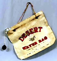
All fluid drive, floating power, full-floating ride….that’s the ’48 De Soto. This 106 horsepower, 3200 pound mush bucket would fully insulate passengers from the harsh experience of the depression and WWII….heater optional. Chrysler Corp. didn’t have an automatic then but figured out a system where you put in the clutch, put the column shift in low, and then took off. You shift up automatically by letting up a bit on the gas. Air conditioning is 4 X 60…four windows down and sixty miles an hour, but the wind buffets so loud in Chrysler cars you can lose an eardrum, soa Car Cooler was handier on a hot day. Oh yeah, and a ‘Desert’ water bag to hang off the front bumper for a cool swig while admiring de Anza’s path.


Not all landmarks visited get a song, but de Anza is addressed in ‘Yuha Well’, a story for a later dispatch on the Imperial Valley.

Blog timeline: Though the baseline for these stories will be chronological from 1993, it’ll skip around from 1952 to present periodically for absolutely no just cause or reason.


Tuesday, December 7, 2010

December 7th 1941

Thanks to those of my father’s generation who served.
A link to the Training Center Boogie video sample:
http://www.youtube.com/watch?v=D4B2-OHe3Lo

Sunday, December 5, 2010

Desert Training Centers

'Get it out this minute, get it in in under ten.’ Imagine a 108 degree day, an angry drill Sgt., full uniform, pack, and rifle, and the command to run your chain smoking self the distance of a mile in under 10 minutes. Welcome to General Patton’s training center of WWII.

California State Historical Landmark No. 985
Desert Training Center California - Arizona Maneuver Area
Plaque inscription:  The D.T.C. was established by Major General George S. Patton, Jr., in response to a need to train American combat troops for battle in North Africa during World War II. The camp, which began operation in 1942, covered 18,000 square miles. It was the largest military training ground ever to exist. Over one million men were trained at the eleven sub-camps (seven in California).

Location:  General Patton Memorial Museum, Chiriaco Summit, from I-10 exit N at Chiriaco Summit, 28 miles E of Indio. Second plaque located 0.2 miles N of I-10 on Cottonwood Springs, then 7/8 mile E on dirt road. (from California Historical Landmarks)
GPS Coordinates:  33º39.697 N - 115º43.334 W

Yep, a little Bardhal helped pull the DeSoto up the grade out of the Coachella Valley just fine, all the way to Desert Center and the Stonehenge of dead palm trees to the Patton museum and the state landmark. The photo is from a second trip in 1995. Seven years later a song is coming together using the 85th infantry division as a base. Later, when putting together material for the booklet, actual photos of the 85th surfaced and the owner was kind enough to lend use. These were my characters, just as they were envisioned.


TRAINING CENTER BOOGIE   © Radio Flier Music                 
Well the sun’s gone down I got a minute to write
A letter to you mama here by candlelight      
No sheets on my cot in this tent we’re in
Somebody said today it was 110
No refrigerator no electricity
At Desert Training Center that’s the way it has to be

You know I joined this army to get into the war
Dancing the desert, June of 1944
Waltz with the cactus do the shuffle with the sand
Swing with the buzzards jitterbug when we can
But there’s a special one we do and it’s a goodie
A little jive dance we call the Training Center Boogie

Ch) Training Center boogie’s not a dance you see
A mile run in the sun when it’s 103
Full pack and a rifle here we go again
Get it out this minute, get it in under ten

We’re getting up tomorrow at a quarter to four
Marching to the boarder on the desert floor
Then it’s rations with a passion in the noonday sun
Can’t wait to get started it really sounds like fun
March back to camp in the afternoon
Thank you Mr. Sergeant for this lovely day in June

 It won’t be long we’re hearin’ when the order comes around
We’re going of to Europe, put old Hitler down
This 85th division of the infantry
Gonna dance on Hitler’s grave for everyone to see
Cause there’s a special one we do and it’s a goodie
A little jive dance we call the Training Center Boogie


Database

This map should give the reader an idea of how it was done. Detective work at its core, imagine the brown suit, and fedora in a ’48 DeSoto business coupe, necking knob on the bakelite steering wheel for U-turns, and a pack of Camels with rolled change for the operator’s directions.   
Somewhere in the analog first days of landmark hunting, it was decided to keep a record of events, along with photo scrapbooks and notebooks filled with skewed directions. Remember, it was the ‘pre decent computer’ era and my Apple IIC wasn’t capable of much beyond ‘Lemonade Stand,’ so things were simply checked off in the California Historical Landmarks book. Landmarks there were divided by county with indexes at the end, so they’d get circled as things rolled along. The date entered, along with skier’s icons for degree of difficulty and a smiley face with varied degrees of satisfaction to an un-smiley face. Eyes glazed yet?

Dad gum, that system worked well. Today, everything is on an Excel database and there are 5 columns using letter symbols for ‘yes’ and ‘no’ and ‘excellent’ to ‘poor’ and  2 columns in some cipher from the cold war. Though the rest of the information like name, county, number, date, description, and coordinates remain, it sure would be nice to know what was meant.

There was the foresight to begin entering GPS coordinates about 10 years ago and retroactively hunting down waymarking groups with accurate information to sights already visited. Hours, and in a few cases, days have been spent looking for a pesky marker in those pre navigation device days, and with over 90% covered with GPS, the old database is the mother lode.