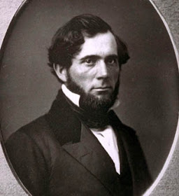
Kit Carson
Alpine County August 4, 2009
From the
Old Emigrant Road marker we head east on highway 88 for three miles. It was this route Kit Carson had picked using information obtained from Washoe Indians to guide the
Fremont expedition out of
Nevada and over the Sierra to Sutter’s Fort in winter conditions in early 1844. And sure enough, as the Washoe had warned, there was no food or game along the way the they had to resort to eating some of their dogs, horses, and mules.
'Kit Carson Marker' actually denotes the spot he carved his name on a tree.
John C. Fremont
There’s a pastoral place in
Snake Valley,
Utah named
Pruess Lake, not for the hybrid
Toyota but for Charles Preuss, the melancholy ‘old guy’ cartographer on the
Fremont expeditions. While it seems as if everything in sight was either named Carson or Fremont from these early expeditions, the best Mr. Preuss could get was that small body of water in rural
Utah…and misspelled at that.
Charles Preuss
As well as being a mapmaker, Preuss was an artist, and the illustrations he made of the expeditions were engraved and accompanied the published reports, for just like Facebook or a blog, it’s simply better with pictures. The maps and guidebooks from the expeditions became best sellers and helped the country expand to the Pacific. But again, all Preuss got out of it was temporary employment.
It was a bit like a serial western, with
Fremont as the heroic Lone Ranger and Kit Carson as Tonto, his trusty sidekick. And then there was Preuss as the grumbling tenderfoot they needed to bring along.
To that trio of main characters,
Fremont hired a group of cherry-picked civilians that were French-Canadian and American, seasoned hunters and trappers that could endure the hardships without complaint. Just about all of them were illiterate, so written record of the goings on were confined to Fremont’s notes and Preuss, who kept a diary for his wife. Biographers had to rely on
Fremont field notes which were remembered and often enhanced after the fact, for the existence of Preuss’ notes were unknown. It turned out they had remained in his family and were found in the early 1930’s in his native
Germany after a derivative ‘memoirs of a northern
California pioneer’ was published. Attempts to retrieve the notes came to a halt with Hitler coming to power and eventually they were found in the American Memorial Library in
Berlin in the 1950’s.
As it turned out the notes were mostly complaints about food and long hours in the saddle, along with tart observations of
Fremont’s leadership and decision-making process. When combined with
Fremont’s notes however, a good account of the first three of the four expeditions can be had. Preuss diary also exposes his weltschmertz;
that unique German word meaning roughly a growing world-weary sadness. That sadness eventually got to Charles Preuss and he committed suicide in 1854 at the age of 51.
The fold out from the 1845 report showing the 1844 route of the winter crossing of the Sierra Nevada. It begins on the East Fork of the Carson River near Markleeville, Ca (on the right) and ends at Sutter's Fort at New Helvetia (Sacramento) near the American and Sacramento Rivers.
Plaque inscription: NO. 315 KIT CARSON MARKER - On this spot, the summit of the Kit Carson Pass, stood the Kit Carson Tree on which the famous scout Kit Carson inscribed his name in 1844 when he guided the then Captain John C. Frémont, head of a government exploring expedition, over the Sierra Nevada. The original inscription was cut from the tree in 1888 and is now in Sutter's Fort, Sacramento.
Location: On State Hwy 88 (P.M. 5.2), 14.5 mi W of Woodfords
GPS 38.694889,-119.989007


