Wednesday, August 31, 2011

Mission San Gabriel Archangel


Los Angeles County, September 7, 1995

If you look at a map of the 21 Spanish missions from San Diego to San Francisco, you’ll notice that they conveniently follow highway 101 for the most part and are fairly evenly spaced at about thirty miles. That distance was about a day’s journey in the late 18th century, and puts two of them in Los Angeles County; San Fernando, and San Gabriel.

The goal of the Spanish government was to recruit local First Nation peoples, then convert, educate, and ‘civilize’, turning them into Spanish colonial citizens. Total assimilation of native populations into European culture and the Catholic religion was a doctrine established in 1531 in Spain. They sent missionaries to help construct and operate each mission, and did introduce modern foods, trees, cultivation methods to produce crops, and livestock to areas where fish and wild game were traditional, but small pox, measles and other diseases also arrived, decimating native populations in many cases. The Mexican Congress passed the Act for the Secularization of the Missions of California in 1833 called for the colonization of both Alta and Baja California from proceeds of the sale of the mission property to private interests.


Mission San Gabriel Archangel was one of the earlier ones, having begun in 1771 and eventually grew to a large structure with a high bell tower, which, after being destroyed in an earthquake, was redone as a companario incorporated into the walls, as we see it today.


Bells were used in the missions to call everyone to the church for services starting at sunrise, to communicate the time of day and to regulate daily life in the community. The bells used in the early missions were sent by ship Mexico and were considered essential in founding a new mission where they were hung from poles until a church could be built. San Gabriel’s six bells occupy the espadaña or bell wall. The oldest bells were cast in Mexico City in 1795 by the famous bell maker, Paul Ruelas, and the largest bell (dated 1830) weighs in at over a ton.

Though their website appears to currently be under the weather, the mission complex is still very active and their annual Labor Day fiesta is coming up this weekend.


In developing the album of songs devoted to landmarks in Los Angeles County (called County of Angels), it became apparent that if a timeline format was to be used, something about the mission era was essential. The approach taken was to write something simple and melodic, with a Spanish feel, and sound like it’s already been around a long time. A video sample will most likely show up on YouTube in the near future.  

BELLS OF SAN GABRIEL © Radio Flier Music

Chime the infant’s new arrival
Confirmation rise and sing
Praise the joy of a wedding
Neath the archangel’s wing

(Chorus) Ring the praises of the savior
Bring the message of the bells
Blessed by the holy father
Mission of San Gabriel

Sound the passing of a patron
Call us to our daily meals
From the campanario
Bring us home from the fields

 Plaque inscription: NO. 158 MISSION SAN GABRIEL ARCÁNGEL - The mission was founded September 8, 1771 by Padres Pedro Benito Cambon and Angel Fernández de la Somera. The present church building was begun during the latter part of the 18th century and completed in the year 1800.
Location: 537 W Mission Dr at Junipero St, San Gabriel USGS Quadrangle Sheet Name: EL MONTE
Listed on the National Register of Historic Places: NPS-71000158
Google maps: 34.097546,-118.108606

Sunday, August 28, 2011

Pioneer Memorial Cemetery


Los Angeles County, June 21, 1995

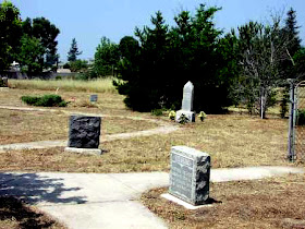
The landmark for what was formerly called Morningside Cemetery is easily found on corner of a lightly maintained ‘natural state’ plot of about 4 acres where about 750 people were put to rest till 1939 when it came to rest as well. Mortician Will Noble had bought it from a group called the San Fernando Cemetery Association when they dissolved, and when Will went in ’39, so did the cemetery.  


In 1959, the San Fernando Mission chapter of the Native Daughters of the Golden West took it over and named it Pioneer Memorial Cemetery, and are responsible for making it a state landmark. In 2002, the Native Daughters quit claimed it over to the San Fernando Historical Society, who are still looking for assistance and preservation of the site.

Over the years, vandals have had thier way with headstones and the Sylmar quake delivered some damage, but overall, it could be a lot worse. Still, watered grass would be nice.


Plaque inscription: NO. 753 SAN FERNANDO CEMETERY - Earlier known as Morningside Cemetery, this is the oldest nonsectarian cemetery in San Fernando Valley. It was used from the early 1800s until 1939, it was legally abandoned in 1959, when Mrs. Nellis S. Noble donated the site in memory of the pioneers of San Fernando.
Location: SW corner of Bledsoe and Foothill, Sylmar
Google maps: 34.320995,-118.448142

Saturday, August 27, 2011

Griffith Ranch


Los Angeles County, June 21, 1995


Just off the 215 freeway, it would be nice to say there’s still an active ranch dedicated to the film industry, or a museum, or something other than the reality that it’s a unassuming landmark on the northeast corner of Foothill and Vaughn acting as part of the perimeter fence of what was then a bolt factory and is now a propane yard. Time marches on. Shoot, this is D.W. Griffith we’re talking about, the guy who invented Hollywood, and ‘Birth of a Nation’ was filmed here.


While here, there was this feeling of having been here many times before, which as it turns out, was a block away where the top end of San Fernando Raceway ended at Foothill and where this writer’s dragster crashed in 1966.  As part of the land shared with long gone San Fernando Airport, the drag strip was run (mostly by Henry Hibler) from 1950 to 1969….and like the ranch, made its way into numerous TV and film spots. Race day was Sunday, and local noise abatement ordinances allowed for only three hours of competition (12:30 to 3:30) ‘without mufflers’, so it was a Chinese fire drill to qualify and go through a field of eight for the $250 top eliminator prize. It was one of the few places we, as fledgling top fuel racers, actually had a chance at winning. Memories are mostly of the incredibly high track temperatures and sitting strapped in a fire suit and drinking the giant 50 cent cups of pink lemonade nonstop through a straw under the mask.


As to the crash, this writer was baffled by a glitchy clutch action that was grabbing too early and asked driver Bob Hightower to take shot at it. By putting extreme force on the handbrake he was able to hold it at the line but that proved costly on the top end for the brake handle came off in his hand. Add to the that the chute didn’t deploy and he was in deep snow on a track with a notoriously short shutoff area…something like 1500 feet before reaching the concrete overhead arch that was Foothill Boulevard, and the pole in the middle with the little sign that said: ‘Spin Out Area’.  Bob thought quickly and slowed the car some by coming down on engine compression before dodging the pole and flipping the car on the rocks on the other side. Miraculously, he was uninjured and we actually gained a sponsor out of the incident for one of the people helping extract Bob was the owner of Chute Metal Products in Tarzana, a maker of drag chutes, harnesses, and racing safety equipment, and my running mouth of how crappy our parachute was led to his correction that it was actually my dimwitted mounting of the chute and general lack of knowledge of the aerodynamics that make them work, led to a great relationship once we all cooled down.  
 

Plaque inscription: NO. 716 GRIFFITH RANCH - Originally part of the San Fernando Mission lands, this ranch was purchased by David Wark Griffith, revered pioneer of silent motion pictures, in 1912. It provided the locale for many western thrillers, including Custer's Last Stand, and was the inspiration for the immortal production, Birth of a Nation. In 1948 it was acquired by Fritz B. Burns, who has perpetuated the Griffith name in memory of the great film pioneer.
Location: 12685 Foothill Blvd at Vaughn St, San Fernando
Google maps: 34.289834,-118.411267


Friday, August 26, 2011

The Cascades


Los Angeles County, June 21, 1995


The song, ‘The Cascades’ was written earlier this month (August, 2011) and is part of the album; ‘County of Angels’, a musical look at the stories behind some of the landmarks in Los Angeles County in a timeline format from First Nation people to the Beach Boys. This song is a whole lot of fun to play and  has a spoken narrative lyric with a sung chorus. A video sample will be up on YouTube sometime in the future.


THE CASCADES                  © Radio Flier Music

On November 5, 1913, William Mulholland woke up a happy man
30,000 people coming to celebrate, the day the water came in

By buggy, wagon, car & rail, to watch the water cascade down
And pour out of the hills of Newhall, into Los Angeles town

Then the band stopped, the crowd got quiet, he stood high in the morning air
He thanked the crew and financiers, but speeches were just not his fare

He said “This rude platform is an alter, and on it we dedicate for all time”
The crowd came to see the water run, so short speeches were just fine

(Chorus) And the water came tumblin’ tumblin’ tumblin’
The water tumbles away
All the way from the high sierras
For the town of LA …. down the great cascade

He paused as if he was forming words, and simply said “That’s all”
The people roared as he sat down, for soon the water falls

Time came to call him back, to give the sign to open the valves
Men turned the hilltop wheels, and water tumbled down the canal

And the crowd went nuts….filling cups like water was candy
And for a reason no one knows, the band played ‘Yankee Doodle Dandy’

The speech to turn the aqueduct over, was scrapped ‘cause it just wouldn’t fit
Mulholland simply turned and said “There it is Mr. Mayor, take it!”   (Chorus) 

To this day, water cascades down, and Mulholland slept a happy man
But in fifteen years his alter perished, with the collapse of his St. Francis Dam (Chorus)


Plaque inscription: NO. 653 THE CASCADES - This is the terminus of the Los Angeles-Owens River Aqueduct, which brings water 338 miles from the eastern slopes of the Sierra Nevada to the City of Los Angeles. Begun in 1905, the great aqueduct was completed November 5, 1913. The Mono Craters Tunnel project, completed in 1940, extended the system 27 miles to its present northernmost intake near Tioga Pass. Location: 0.1 mi N of intersection of Foothill Blvd and Balboa Blvd, 4 mi NW of San Fernando
USGS Quadrangle Sheet Name: MINT CANYON
Google maps: 34.323653,-118.499104


Thursday, August 25, 2011

Fred Nelles Reform School


Los Angeles County, May 25, 1995

At the time of this visit in 1995, the facility was still open, but due to a lack of funding and shifts in corrections philosophy, the last boy walked out in 2004 after a 113 year run. So today, a drive down Whittier Blvd. will take you past the 74 acre site sporting a chain link fence and overgrown landscaping as it sits in limbo with the historical status that you can’t simply tear it down, while townsfolk don’t what it to become a prison again.


OAC photo - about 1895

The original concept was to truly reform the kids, and it had a reputation for excellent training in the trades and music, but along the way, a 'boot camp' model was adopted and it simply became a big house for little people.


cir. 1900


Since closing, the place has become a favorite haunt for fans of the haunted, and who can blame them, for with ongoing investigations of bodies secretly buried and abuse, etc., there’s lots to explore. It has also become a popular location for the film industry with ‘Blow’ ‘Red State’ and the series ‘Prison Break’ being filmed there, along with many others.


cir. 1900


NO. 947 REFORM SCHOOL FOR JUVENILE OFFENDERS (FRED C. NELLES SCHOOL) - The March 11, 1889 Act of the California Legislature authorized the establishment of a school for juvenile offenders. Dedication and laying of cornerstone was done by Governor R. W. Waterman on February 12, 1890. Officially opened as 'Whittier State School' for boys and girls on July 1, 1891. Girls were transferred in 1916 and only boys have been in residence since that time. Renamed 'Fred C. Nelles School for Boys' in 1941 ('For Boys' was  dropped around 1970). This school has been in continuous operation serving the needs of juvenile offenders since 1891.
Location: Department of the Youth Authority entrance, 11850 E Whittier Blvd, Whittier
USGS Quadrangle Sheet Name: EL MONTE
Google maps: 33.979066,-118.049474


Wednesday, August 24, 2011

William Workman Homestead


Los Angeles County, May 25, 1995


The City if Industry was envisioned as a community devoted solely to commerce. It’s two miles-wide and 14-miles long and lies between two transcontinental railroad tracks in what was a former agricultural area in the south San Gabriel Valley. Although 70,000 workers are in the city by day, only 580 people actually lived within its boundaries at the time of this visit. Today, that population by the 2010 census has dwindled down to 219. At that rate, the town should be empty by 2020.

Yet for all its unattractiveness, the City of Industry is home to a couple of interesting sites; the fake TV McDonalds, and the Homestead Museum. Unfortunately, you can’t do a walk through of the fast food king’s cosmetic morphing building where nearly every commercial and most movies featuring the golden arches has been shot. You can however take a guided tour of Homestead Museum featuring the Wm. Workman home.

 William Workman came to California in 1841 from Taos, New Mexico and though he wasn’t an official landowner until 1845 but had been on the rancho since his arrival. During the Mexican-American war Governor Pico hung out at workman’s place for a spell rather than surrender to US forces in Los Angeles, and as a result, Workman was considered by some to be hostile to the ‘American cause’. Still, he was at the right place at the right time, for gold had just been discovered and the rush was on, and his cattle ranching, leather works, and distilling talents made him a wealthy man.

The museum is host to a wide range of special events, and is open for guided tours.


NO. 874 WORKMAN HOME AND FAMILY CEMETERY - William Workman and John Rowland organized the first wagon train of permanent eastern settlers, which arrived in Southern California on November 5, 1841. Together they owned and developed the 48,790-acre La Puente Rancho. Workman began this adobe home in 1842 and remodeled it in 1872 to resemble a manor house in his native England. He also established 'El Campo Santo,' this region's earliest known private family cemetery, in 1850, the miniature Classic Grecian mausoleum was built in 1919 by grandson Walter P. Temple.
Location: 15415 E Don Julian Rd, City of Industry
USGS Quadrangle Sheet Name: EL MONTE
Google 34.019132,-117.965430


Friday, August 12, 2011

Paradox Hybrid Walnut Tree


Los Angeles County, May 25, 1995


What do you have if you have nuts on the wall? Walnuts. Arguably the most famous tree in Whittier, among the more than 40,000 under the jurisdiction of the City's Parks Department, is this Paradox Hybrid Walnut Tree. It is a cross between an English Walnut and Black Walnut, and is fast-growing. It's located in Roadside Rest Park on Whittier Blvd between Mar Vista Steet and a street named after me..... Penn Street.


In 1955 it was saved through the efforts of the native Daughters of the Golden West and the Daughters of the American Revolution. The Tree, a National Landmark, as well as designated State Historical Landmark 681 in 1959 and on the Local Official Register of Historic Resources. Two dedication plaques were placed near the tree in 1963.

"Paradox" is the actual name of the tree variety, and named by Luther Burbank at the turn of the 20th century for its ‘paradoxical vigor’. The Paradox is an F1 (1st Generation) hybrid of the native Northern California black, crossed with the English Walnut. Presumably, this makes for a better walnut, or there wouldn’t have been so much landmarks fuss.  


NO. 681 PARADOX HYBRID WALNUT TREE - Planted in 1907 by George Weinshank and assistants under the direction of Professor Ralph Smith as part of an experimental planting for the University of California Experiment Station, this tree stands as a monument to the early cooperation of state educational system with local walnut industry.
Location: 12300 Whittier Blvd at Mar Vista, Whittier USGS Quadrangle Sheet Name: VENICE
Google 33.973754,-118.045939

Thursday, August 11, 2011

Grave of Greek George


Los Angeles County, May 25, 1995


Greek George’s coming to America hinged on a little known aspect of Jefferson Davis’ life, and that is that before the civil war, he was the US Secretary of War and got the idea to camels to access and deliver mail and goods to the remote parts of the west, and supply the construction of the Butterfield Stage route. And it worked, the drovers were able to cover almost forty miles each day, and go ten days without water, each animal carrying 600-800 pounds, roughly four times that of a pack mule. And they had an amazing instinct to find water. The main drawback was their hooves, which were suited for sand and not rocks. Throw in bad manners and smell and mules were the better long term choice.  

The troops had to be taught how to work these camels so handlers were brought over along with the animals. Most notable among them were a Syrian named Hadji Ali; who became known as “Hi Jolly,”  and to a lesser extent, Yiorgos Caralambo, who’s name evolved into Greek George. In looking into Hadji a bit, a long standing curiosity has been answered, and that is what the strange gravesite and monument about a camel driver was all about in Quartzsite Arizona that was stumbled upon some years ago.


Greek George was of Greek ancestry, but was living in Smyrna, Turkey, when he was selected for the Camel Corps. Through his service he met Major Henry Hancock, a Harvard trained lawyer and wealthy Los Angeles landowner. Hancock was so impressed by George’s dedication that he wanted to employ him privately and allowed George to build a farmhouse with stables.

The Army disbanded the Camel Corps in 1862, and George was forced to turn the camels into the wild, where they roamed the area for at least thirty years afterwards.


On May 5, 1874, Tiburcio Vasquez, the notorious bandit, was captured while hiding out in a shack behind Greek George’s home. Vasquez, who terrorized Southern California for over twenty three years, often used Greek George’s farmhouse as one of his numerous hideouts. Hmmm….it isn’t known if Greek George harbored or informed on the outlaw. Greek George later mover to Montebello and died near Mission San Gabriel in 1913.


NO. 646 GRAVE OF GEORGE CARALAMBO, (GREEK GEORGE) - This is the grave of 'Greek George,' a camel driver from Asia Minor who came to the United States with the second load of camels purchased by the War Department as an experiment to open a wagon road to Fort Tejón from Fort Defiance, New Mexico. Because of the Civil War, the experiment was abandoned. 'Greek George' became a naturalized citizen in 1867 under the name of George Allen. He built an adobe home on Santa Monica Boulevard.
Location: Founders' Memorial Park, Broadway at Gregory Ave, Whittier (gravestone in storage, 1993)
USGS Quadrangle Sheet Name: WHITTER
Google 33.986788,-118.045998


Monday, August 8, 2011

Rio San Gabriel Battlefield


Los Angeles County, May 25, 1995

Out in Montebello just a hair down Bluff road from the intersection with Washington Blvd. and by the Rio Hondo bike path, lies the marker along with two cannon that signify Mexico’s last stand in California. The area is still a river bed with plenty of vacant lots for re-enactors to stage their annual shindig.


Re-enactors


After the battle of San Pasqual, the battered Army of the West commanded by General Stephen W. Kearny went to the headquarters of Commodore Robert F. Stockton at San Diego. That previous December, Kearny’s men holed up on Mule Hill, where they lost 17 men and forced to eat their mules to stay alive while Kit Carson and Edward Beale snuck off and got help from San Diego. Stockton's next objective was to recapture Ciudad de Los Angeles. That settlement had been previously captured by Stockton's forces, but was left in the command of Lieutenant Archibald Gillespie and had been lost to the Mexicans milita, commanded by General José Mariá Flores.

Kearny and Stockton initially disputed command. Although Kearny had rank and superior orders from the War Department, he had previously sent most of his troops back to Santa Fe, believing that the war in California was over. Stockton had a larger force, and knew the area, so Kearny did not initially dispute Stockton's command of the campaign to recapture Los Angeles, which departed San Diego in late December with Stockton's force of over 500 seamen and marines, as well as Kearny's remaining force of about sixty dragoons.


In ‘odd couple’ fashion, Kearny ordered the artillery to cover the crossing but Stockton countered the order and began to move across the river. The crossing proved to be especially difficult as Flores was in a good position to contest the crossing from the heights across the river and the ford had patches of quicksand at the bottom of the knee deep water.The U.S. force came under fire as it crossed, but due to poor ammunition and bad aim the Mexican artillery proved to be ineffective. Stockton directed the artillery, which silenced both Mexican cannon. The left flank took a Mexican hilltop position and held it against a counterattack. Then the whole main position charged forward shouting "New Orleans, New Orleans" in honor of Andrew Jackson's victory there in the war of 1812. The charge took the heights and Flores withdrew in good order. The battle had lasted only an hour and a half, but it was decisive in the campaign for Los Angeles. Even though the battle of New Orleans was 31 years prior, it still seems like the word was yet out that that battle took place weeks after a treaty was signed.  


NO. 385 RIO SAN GABRIEL BATTLEFIELD - Near this site on January 8, 1847, American forces commanded by Captain Robert F. Stockton, U.S. Navy, Commander in Chief, and Brigadier General Stephen W. Kearney, U.S. Army, fought Californians commanded by General José María Flores in the Battle of the Río San Gabriel.
Location: NE corner of Washington Blvd and Bluff Rd, Montebello
Los Angeles County, May 25, 1995
Google 33.992059,-118.11122


Sunday, August 7, 2011

Hugo Reid Adobe


Los Angeles County, May 25, 1995 and still at the Arboretum

As mentioned in a previous dispatch, the better half’s ancestors are tied into the history of this part of Los Angeles County in a big way. Though her direct ancestor, George Dalton gravitated to LA proper and owned 160 acres (mostly vineyards) at what is now the Farmer’s Market area, it is his older brother Henry that is of interest. 


Henry Dalton


Henry Dalton was born in England in 1803, and in 1820 sailed to Lima Peru and became a merchant eventually commanding a small fleet of merchant vessels. By 1841 he had become a prominent figure in California coastal trade. Dalton chose Rancho El Susa as his home renaming it Azusa de Dalton. Dalton built a house here on a place known as Dalton Hill, near 6th Street and Cerritos Avenue in Azusa. The Rancho Azusa Dalton lay east across San Gabriel River from the Rancho Azusa De Duarte. The first was often called El Susa, and the latter Susita. Dalton further increased his holdings to include the Rancho San Francisquito and Rancho Sant Anita. In the end Dalton owned an unbroken expanse of land from the present day San Dimas to the eastern edge of Pasadena.

With California in the United States following the Mexican-American War, the 1848 Treaty of Guadalupe Hidalgo provided that the land grants would be honored. After filing his claim for Rancho Azusa de Dalton with the Public Land Commission, as required by the Land Act of 1851, Dalton disagreed with the 1860 US survey by Henry Hancock, and borrowed money from J.S. Slauson to fight the case through the courts. The courts decided against him after 24 years of litigation. Consequently in 1885, Dalton turned Rancho Azusa over to Slauson, who deeded a 55-acre homestead to Dalton. Henry Dalton received a US patent for Rancho Azusa in 1876. When he died in 1884, Dalton had lost most of his property and was living in poverty. As mentioned earlier, in the 1880 census he gives his occupation as ‘Fighting for his rights’.

Though Henry Dalton owned this land that is the site of Queen Anne Cottage, and the Hugo Reid Adobe, it is likely Lucky Baldwin acquired it through the public land commission after the Hancock survey took the land from Henry, who ultimately lost his claim in a U.S. Supreme Court decision.   

It’s interesting to note Henry Dalton is a great great  grandfather of singer Linda Ronstadt. 


So who was Hugo Reid? According to the 1953 book “Arcadia, City of the Santa Anita,” by Gordon S. Eberly, he was a tall, good-looking fellow with keen blue eyes. After an unhappy love affair he left Scotland and his family at the age of 18 and sailed to the port of San Pedro and made a trip to Mission San Gabriel. He was so taken with the beauty of the San Gabriel Valley that he moved permanently to Los Angeles in the summer of 1834. Two years later the woman’s husband died of small pox. Reid, by then called Don Perfecto Hugo Reid at the age of 27, converted to the Catholic church to appease and marry the 29-year-old widow, then called Dona Victoria and now the mother of four children.

The Reids became widely known for entertaining with lavish meals and relaxing ranch life at the Rancho Santa Anita. But by 1842 Reid is said to already have grown restless and tired of ranch life and spent the next few years traveling to foreign countries on his new trading vessel.

In the meantime, Victoria could not keep up with the needs of the rancho and maintenance was becoming a financial burden. Only two years after obtaining full title on the Rancho Santa Anita property in 1845, they sold it to Reid’s former business associate Henry Dalton in 1847 for $2,700 (about 20-cents per acre!).

Reid then devoted his time to the San Gabriel Mission (he was appointed administrator by Governor Pio Pico  and wrote a series of notable stories about Indians for the Los Angeles Star before he died at the age of 42 on December 12, 1852.

The adobe was constructed in 1840 with the help of Gabrielino laborers. It was built of sun-dried adobe blocks made by mixing clay soil, water and a straw binder. The roof was made of rawhide-lashed cane. As protection from the elements, the roof was smeared with brea (tar) and the walls were white-washed.

The Hugo Reid Adobe has been reconstructed using original methods and materials whenever possible. Inside you’ll found primitive handmade furniture such as the cowhide beds and rough-hewn chairs.


NO. 368 HUGO REID ADOBE - Hugo Reid, a Scotsman, petitioned the government of Mexico to grant him Rancho Santa Anita. His claim strengthened by his marriage to Victoria, a native Indian of the San Gabriel Mission, he received the grant on April 16, 1841. Immediately upon filing his petition, Reid took possession of the land, started to farm and plant vineyards, and built the first house-the Hugo Reid Adobe-in 1839. In 1875, E. J. Baldwin purchased the rancho and in 1879 added a wooden wing to the old adobe.
Location: Los Angeles State and County Arboretum, 301 N Baldwin Ave, Arcadia
USGS Quadrangle Sheet Name: PASADENA
Google 34.140580,-118.053444

Saturday, August 6, 2011

Baldwin's Queen Anne Cottage


Los Angeles County, May 25, 1995


The Queen Anne Cottage and Hugo Reid Adobe both rest within the grounds of the : Los Angeles State and County Arboretum, and as a result, are among the few state landmarks that require money to see, in this case, it’s now $8 to enter. Though the grounds and programs offered within are wll worth the fee, if you’re simply going to visit the landmarks, it’s worth an attempt at the gate to get a free pass for the fifteen minutes or so it takes to see them…..it’s within the bylaws of the Office of Historic Preservation to do so.


Baldwin - 1903


Elias Jackson Baldwin's Queen Anne Cottage was constructed in 1885-86, probably as a honeymoon gift for his fourth wife, Lillie Bennett who was 16 at the time. "For a year after she married Baldwin (May, 1884), this little girl was queen of the ranch," - Los Angeles Times. Lillie's father was architect Albert A. Bennett, who designed the cottage. Lillie and E.J. separated in 1885, and the house was converted by its owner into a memorial to the third Mrs. Baldwin, Jennie Dexter, who had died in 1881.


The designation "Queen Anne" was added in later years in reference to its architectural style, and became the Santa Anita Ranch guest house. Cooking and dining facilities and Baldwin's personal quarters were located in a modernized 8-room version of the Hugo Reid adobe, found on the property at the time of purchase. Friends, relatives and business associates of Lucky Baldwin, including stars from the Baldwin Theater in San Francisco, enjoyed the ranch hospitality until E.J.'s death in 1909.

Lucky Baldwin generated most of his wealth through lucky mining investments (that's how he got his nickname). Baldwin accumulated landholdings of 63,000 acres in Southern California, where the communities of Arcadia and Monrovia are now located.


Baldwin's matrimonial ventures periodically created news sensations. He was married four times, the first three marriages ending in divorce. He was sued by four women for breach of promise of marriage. Anita Baldwin, one of his accusers who was later reported to be his niece, wounded him in the Baldwin Hotel with a pistol shot in 1883. About ten years later he was shot by Vinnie Ashley who was attempting to avenge his injured sister. His fourth wife and their daughter were at his side when he died at their Arcadia ranch. And they still called him ‘Lucky’.


NO. 367 E. J. BALDWIN'S QUEEN ANNE COTTAGE - Designed by A. A. Bennett for entertaining, the cottage was constructed by Elias Jackson ('Lucky') Baldwin in 1881. Since there was no kitchen, meals were served from the nearby adobe (built by Hugo Reid in 1839) where Baldwin actually lived. The building was restored and dedicated May 18,1954 as part of Los Angeles State and County Arboretum.
Location: Los Angeles State and County Arboretum, 301 N Baldwin, Arcadia
USGS Quadrangle Sheet Name: PASADENA
Google 34.141211,-118.053637

Thursday, August 4, 2011

Site of Mission Vieja


Los Angeles County, May 25, 1995

Just off the 60 freeway near the 605 interchange, this landmark takes us to Montebello and the edge of a park known as the Bosque Del Rio Hondo. The five acre park is part of the 277 acre Whittier Narrows Recreation Area and left in its natural state as wetlands in a floodplain, and that tendency to flood was the reason they moved the mission to its present site San Gabriel in 1775.

It’s rare to see a California state landmark in tablet form and looking more like a tombstone than a marker, but what the heck, it was 1921 and 14 years away from becoming one.  


1921 dedication


It is remarkable how little known is the fact that the Mission San Gabriel was not founded in its current location. Although the mission has been at its San Gabriel site since about 1775, it began in the Whittier Narrows near South El Monte, Montebello and Pico Rivera. A plaque erected by Walter P. Temple and commemorating the founding of the mission on the 150th anniversary in 1921. The site, at the corner of San Gabriel Boulevard and Lincoln Avenue in Montebello, was approved in 1935 as California State Landmark 161. - Paul R. Spitzzeri (Montebello Historical Society)


NO. 161 SITE OF MISSION VIEJA - 'Mission Vieja,' Old Mission, was the name given to the first buildings erected, and later abandoned, by the fathers for Mission San Gabriel Arcángel. The permanent buildings for the mission were located about five miles distant.
Location: SW corner N San Gabriel Blvd and N Lincoln Ave, Montebello
Google 34.030932,-118.073099

Wednesday, August 3, 2011

Casa de Governor Pio Pico


Los Angeles County, May 25, 1995

Right off the 605 and right on the corner of Whittier and Pioneer, this is one of those state historical landmarks that that you’d short list as a recommendation to someone new to landmark hunting.


Pio de Jesus Pico IV was a Californian, born in 1801 at Mission San Gabriel and passed away in 1894 in Los Angeles. Born a poor enlisted soldier's son, Pico gained wealth and status as a businessman and politician in Alta California, and was twice governor of the territory. Pico's power, influence, and wealth continued after California became part of the United States, a well-respected and important leader of his time.

Pico's family migrated to Alta California in 1775 with the de Anza Expedition. Although his father was only a soldier, Pío Pico and his siblings did well in frontier Mexican California society. His seven sisters married into prominent families and his two brothers were active in the military and politics.


Pico's home in 1903


Pio Pico began acquiring this land, originally part of the Mission San Gabriel, in 1848. The smallest of his many landholdings, he nicknamed his 8,893 acre ranch "El Ranchito" (the little ranch). Pico's adobe home was at El Ranchito's center. Pío Pico State Historical Park today includes only a few acres of Pico's original rancho. The survival of the Pico Adobe and the reconstruction of the ranch landscape offers us a rare look into Southern California’s  past.


Photo: 1920's


Pico and his family hosted colorful balls with singing, dancing, and socializing. Such festivities at the Pico Adobe centered around the parlor and the adjoining patio. Pico Americanized his parlor by way of furnishings, wall coverings, and modern conveniences, but the hospitality was purely Californio.


During the 1850s, Pico owned more land than any other individual in Southern California, totaling more than half a million acres. However, like most Californios, Pío Pico took heavy losses trying to prove legal title to his land as required in the new American courts. These cases were expensive to defend and sometimes took decades to clear. Of all the vast ranch lands that he owned, the Rancho Paso de Bartolo was the one that Pico held onto the longest until his final court case was lost, and so was his home at El Ranchito.

 A side note here is the better half’s connection to Pio Pico in that her grandmother’s Dalton family lived in the vicinity at the height of Pico’s prominence. Her direct line was through a George Dalton, but his brother Henry is of particular interest in that he purchased fair and square with documents, three square miles of land from an original Pico grant that is now Azusa, only lose it to the courts in the same processes that stripped Pio Pico of his holdings. You see, the Dalton brothers were born in England. American citizens who owned land prior to California becoming a state had far fewer difficulties. In the 1880 census, Henry gives his occupation as “Fighting for my rights”

 NO. 127 CASA DE GOVERNOR PÍOPICO - Following the Mexican War, Pío Pico, last Mexican governor, acquired 9,000-acre Rancho Paso de Bartolo and built here an adobe home that was destroyed by the floods of 1883-1884. His second adobe casa, now known as Pío Pico Mansion, represents a compromise between Mexican and American cultures. While living here the ex-Governor was active in the development of American California.
Location: Pio Pico State Historic Park, 6003 Pioneer Blvd, Whittier
USGS Quadrangle Sheet Name: WHITTER
Google 33.994060,-118.070401